


Readers Theater Worksheets
New York State History | Regions and Geography RT Script and Mini Readers | Grades 3-5
New York State History | Regions and Geography RT Script and Mini Readers | Grades 3-5
Couldn't load pickup availability
Classroom Use at a Glance
A New York State History mini reader and Reader’s Theater resource for grades 3–5 with original and accessible reading options, fluency practice, historical discussion, source-based extension, and assessment materials.
Classroom Uses Whole Class, Small Groups, Content-Area Reading, Discussion, Assessment, Review view all
- Whole Class
- Small Groups
- Content-Area Reading
- Discussion
- Assessment
- Review
Included Reader’s Theater Script, Original Mini Reader, Accessible Mini Reader, Teacher Guide, Student Worksheet, Answer Key, Quiz, Google Forms Quiz, Vocabulary, Discussion Questions, Challenge Questions, Primary Source Extension view all
- Reader’s Theater Script
- Original Mini Reader
- Accessible Mini Reader
- Teacher Guide
- Student Worksheet
- Answer Key
- Quiz
- Google Forms Quiz
- Vocabulary
- Discussion Questions
- Challenge Questions
- Primary Source Extension
Format PDF, DOCX, Google Forms, ZIP Download, Printable, Editable view all
- DOCX
- Google Forms
- ZIP Download
- Printable
- Editable
Differentiation Accessible Version, Original Version, Mixed Reading Levels, ELL Support, Struggling Readers, Vocabulary Support, Small-Group Support view all
- Accessible Version
- Original Version
- Mixed Reading Levels
- ELL Support
- Struggling Readers
- Vocabulary Support
- Small-Group Support
Overview
Bring New York State History to life with a Grade 4 Reader’s Theater + differentiated Mini Reader set on New York regions and geography. Students explore how physical maps, political maps, historical maps, and transportation maps help explain New York’s mountains, rivers, lakes, cities, boundaries, routes, and regions.
Students use Simeon De Witt’s 1804 map of New York as a source mystery. They learn why one map is not enough, why a quiet-looking place on a historical map should not be mistaken for an empty place in history, and how geography can shape movement, settlement, transportation, and change over time.
This resource is included in the 10-part NY State History Mini Unit:
Make sure this resource format will meet your classroom needs.
Perfect For
- New York State History units
- Grade 4 social studies
- Mixed reading levels in grades 3–5
- Geography, regions, maps, waterways, cities, and source analysis
- One-day lesson, sub plan, review, enrichment, or map-based source extension
Ease of Differentiation
Every assessment option is designed to be answerable from the Reader’s Theater Script and both versions of the Mini Reader (Original & Accessible).
One Challenge Question uses the linked Library of Congress historical map source packet.
Flexible Classroom Use
- Use the Reader’s Theater script for whole-class participation, small-group performance, oral fluency, and discussion.
- Use the Original or Accessible Mini Reader for independent reading, homework, intervention, ELL support, or differentiated groups.
- Assign digitally or print selected student sections.
- Use the map/source extension for written response, challenge questions, homework, or teacher-led discussion.
Skills Addressed
- Reading comprehension across differentiated texts
- Map skills and geographic reasoning
- Physical, political, historical, and transportation map analysis
- Interpreting historical maps as evidence
- Geography and region analysis
- Evidence-based discussion and written response
- Vocabulary development
- Oral fluency and collaborative reading
- Careful source reading and avoiding overclaims from maps
What’s Included
This product includes a zip file consisting of:
Student Text Options
Reader’s Theater Script (~1,700 words | ~FKGL 4.9)
Differentiated character roles
Whole-class or small-group reading
Designed for oral fluency, discussion, and dramatic engagement
Original Mini Reader (~1,500 words | ~FKGL 4.5)
More detailed student reading
Best for stronger independent readers, homework, or deeper historical analysis
Accessible Mini Reader (~1,100 words | ~FKGL 3.5)
Lower reading complexity
Best for mixed-level classes, struggling readers, ELL support, intervention groups, or faster one-day use
Assessment Materials
- Discussion Questions
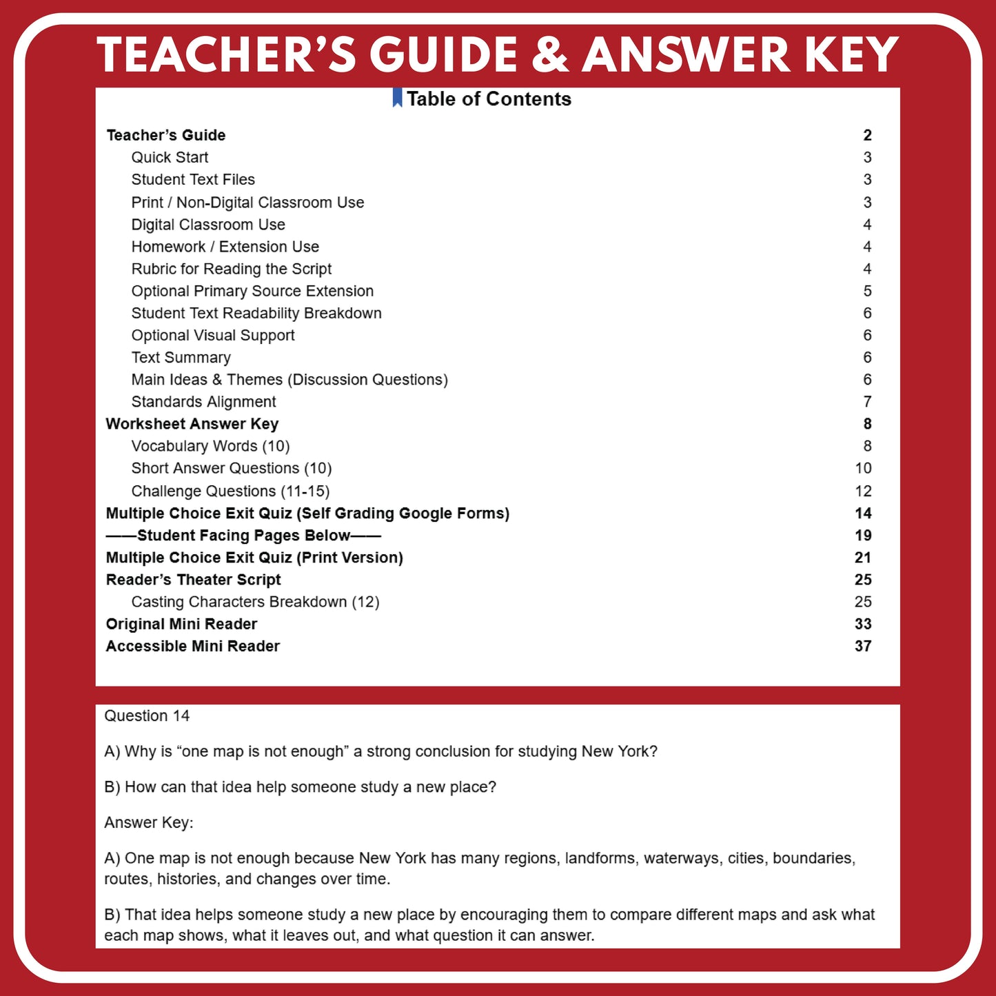
- Student worksheet (10 Vocab Words | 10 comprehension questions | 5 challenge questions)
- 20 Multiple Choice Question Exit Quiz (Self-Graded for Google Forms)
Teacher Materials
- Answer keys for vocabulary, short answer, challenge questions, and print quiz
- Themes and discussion question prompts
- Standards alignment guide
- Optional visual support links
BONUS Leveled Lit Classics Access
Includes student reading access in the Leveled Lit Classics Library making for easy digital kindle-like reading on any device
Text Summary
Students investigate why one map cannot explain all of New York. Through a dramatic Reader’s Theater script and two narrative mini readers, students learn how physical maps, political maps, historical maps, and transportation maps reveal different clues about New York’s geography, regions, movement, and change over time.
Analysis Overview
Students analyze maps as evidence by comparing what different map types show and leave out. They also connect New York’s land and water features to movement, transportation, settlement, and regional identity while practicing careful source claims.
Share